
Point of Interest (POI) Data
Buy point of interest data from GSDSI for geofencing, site selection, measurement, and attribution. Explore database fields, formats, delivery, and licensing, then request a sample scoped to your locations.
Coverage to verify
Test your required geographies, categories, known locations, and difficult same-address cases in a scoped sample.
Refresh terms
Put cadence, change files, corrections, backfills, and closure handling in the order form.
Rights and exclusions
Confirm permitted use, retention, sensitive-location exclusions, and any optional data joins in writing.
Since 2018
Privacy-safe enterprise data
VOSB & SDVOSB
U.S. Veteran-Owned, Service-Disabled
SCC Transfers
EU/UK/CH per privacy policy
GDPR · CCPA · CPRA
Consent-first data sourcing
What is point of interest (POI) data?
Point of interest (POI) data is a structured catalog of real-world places that connects business identity, category, address, operating status, and mapped geometry. Buyers use it to define locations consistently before running geofencing, foot-traffic measurement, site-selection, competitive benchmarking, or attribution workflows.
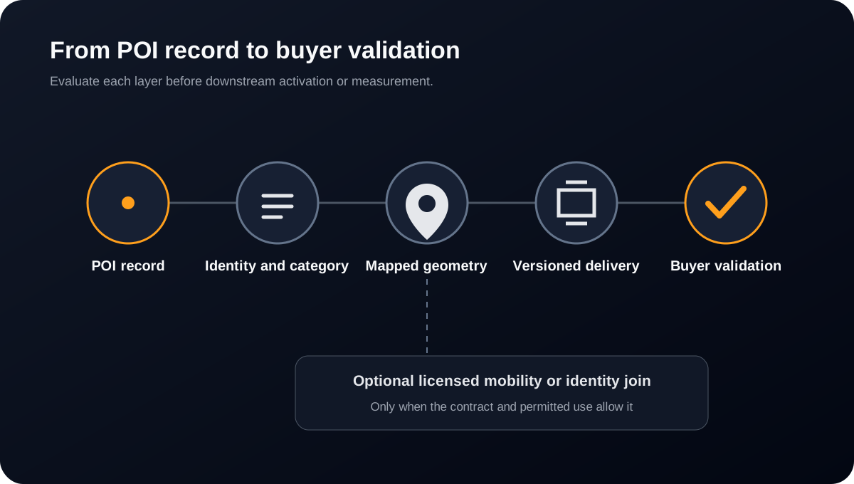
How to evaluate a GSDSI POI sample
Start with locations you already know, including dense retail, adjacent businesses, multi-tenant addresses, recent openings, and closures. Review place identity, category, address, mapped geometry, lifecycle fields, provenance, and permitted use separately before agreeing to production scope.
What's in the POI database
GSDSI point of interest data describes places through identity, brand, category, address, geometry, status, and refresh information. Use the sample schema to confirm field availability for your geography and category.
| Field | What it contains |
|---|---|
| Place identity | A stable poi_id identifies the place record so your team can join location data across workflows. |
| Brand | Brand-to-parent hierarchy connects individual locations to their parent brand for rollup analysis. |
| Category | NAICS classification describes the type of business for category-level filtering and analysis. |
| Address | The place address helps match records to your location list and review businesses sharing an address. |
| Geometry | Polygon boundaries describe the location footprint; latitude and longitude describe its centroid. Confirm polygon availability and fallback rules in the sample. |
| Status | Operating status helps distinguish active and closed locations. Confirm how openings, closures, and rebrands are represented. |
| Refresh | Refresh information helps assess record freshness. Confirm the available update fields, delivery cadence, and change-file behavior in the sample and order form. |
How to buy POI data from GSDSI
Request a scoped sample
Send your geography, chain list or category, required fields, and intended use through the sample request. Review the POI dataset against locations you know before agreeing to production scope.
Choose formats and delivery
POI file formats include CSV, JSON, and Parquet. GSDSI delivery options include S3, SFTP, API, and Snowflake. Confirm the available path for your scoped POI dataset, refresh schedule, and schema in the order form.
Agree licensing and permitted use
Buy POI data through a directly licensed, scoped commercial agreement. Pricing depends on geography, fields, refresh, delivery, and intended use. The signed license defines permitted analytics, activation, and measurement uses, plus joins, retention, exclusions, and downstream sharing. Review optional mobility or identity data rights separately.
POI data provider: what to compare
Compare a POI data provider on coverage for your locations, geometry, brand hierarchy, source transparency, refresh, delivery fit, and permitted use. Use the same sample scope for each provider.
Read the POI data provider comparison checklistPolygon-capable POI data compared with a centroid-only place file
Use this buyer framework to inspect the sample and define acceptance criteria. It describes evaluation questions, not a universal guarantee for every geography or category.
| Criterion | Polygon-capable feed | Centroid-only file | What the buyer should test |
|---|---|---|---|
| Geometry | Mapped boundaries where available, with an explicit fallback policy | A single coordinate that usually requires a radius assumption | Inspect dense, adjacent, and multi-tenant locations in the sample |
| Place identity | Location, brand, category, and address can be evaluated as separate fields | A pin may not distinguish neighboring businesses or brand hierarchy | Match a known chain list and review same-address exceptions |
| Lifecycle | Status and change handling can be specified in the delivery agreement | A static list can hide openings, closures, and rebrands | Define how updates, corrections, and deltas will be communicated |
| Evaluation | Supports record-level review before downstream measurement | Often requires additional assumptions before activation | Set acceptance criteria before licensing production data |
Methodology, limitations, refresh, and permitted use
Document these four areas during sample review so technical, procurement, and compliance teams evaluate the same scope.
- Methodology
- Evaluate place identity, category, address, operating status, and geometry independently against locations you already know. Define acceptance criteria before a production license.
- Limitations
- Coverage, completeness, and geometry availability can vary by geography, category, and source. A scoped sample is the appropriate way to test the locations that matter to your use case.
- Refresh
- The order form should define delivery cadence, change files, closure handling, corrections, backfills, and notice for schema changes. Do not infer a refresh commitment from a generic product description.
- Permitted use
- POI records and any optional mobility or identity joins have separate usage rights. The signed license controls joins, retention, sensitive-location exclusions, activation, measurement, and downstream sharing.
Use cases by industry
Retail & QSR
Competitive benchmarking, trade-area overlap, and share-of-visit by brand or category.
OOH & CTV
Geofence audiences, exposure-to-visit attribution, and screen-level planning.
Commercial real estate
Site selection, co-tenancy reads, and portfolio benchmarking on polygon truth.
Location intelligence
Foot-traffic measurement, origin-destination, and panel joins on shared POI IDs.
Request a POI data sample
Scope a chain list, category, or geography, then define the fields and acceptance criteria your team needs to evaluate.
Request a POI data sampleFrequently asked questions about POI Data
What is point of interest (POI) data?
Point of interest (POI) data is a structured catalog of real-world places that connects business identity, category, address, operating status, and mapped geometry. Buyers use it to define locations consistently before running geofencing, foot-traffic measurement, site-selection, competitive benchmarking, or attribution workflows.
Where can I buy POI data?
You can buy POI data directly from GSDSI through a scoped commercial license. Request a sample with your geography, chain list or category, required fields, and intended use. Review the sample, then agree pricing, delivery, refresh, and permitted use in the signed order form.
What does a POI database include?
A POI database includes place identity, brand hierarchy, business category, address, mapped geometry, operating status, and refresh information. GSDSI lists POI identifiers, polygons, centroid coordinates, NAICS codes, parent brands, and opening hours where available. Confirm the exact fields and completeness in your scoped sample.
Where does POI data come from?
POI files can draw from licensed business listings, public records, imagery, operational web signals, and field validation. Ask each provider to identify its source categories, validation steps, refresh process, and known limitations for the sample you are evaluating.
How is POI data collected?
GSDSI combines business registries, commercial data partnerships, satellite and aerial imagery verification, and crowdsourced validation to build its POI database. Records are geocoded and classified, with brand relationships mapped to parent companies. Ask which sources and validation steps apply to your sample and how source conflicts, openings, closures, and corrections are handled.
What is POI data used for?
Common uses include retail benchmarking, geofence design, site selection, trade-area analysis, and attribution. Any mobility or identity join should be evaluated separately for match logic, permitted use, retention, exclusions, and measurement methodology.
How accurate is POI data?
Accuracy depends on the buyer’s use case. Test known locations, dense retail, adjacent businesses, multi-tenant addresses, category consistency, geometry, openings, closures, and correction handling rather than relying on record count alone.
How often is POI data updated?
Refresh needs vary by use case. Define cadence, full versus change-file delivery, closure handling, corrections, backfills, schema changes, and service levels in the order form rather than inferring a commitment from general marketing copy.
How much does POI data cost?
Ask for a quote tied to the exact geography, categories, fields, delivery path, refresh terms, permitted use, and support your program requires. Compare total contract scope and acceptance criteria rather than a headline per-record price.
What's the difference between POI data and place data?
The terms overlap. Some place files provide a coordinate, while POI products may also include business identity, category, hierarchy, address, operating status, or mapped boundaries. Compare the actual fields and fallback rules in the sample.
Is POI data privacy-compliant?
POI records and optional mobility or identity joins can have different privacy and licensing requirements. Review sourcing, sensitive-location exclusions, retention, deletion, activation, downstream sharing, and permitted use with counsel for the proposed workflow.
How do I evaluate a POI data provider?
Test known locations, dense retail, adjacent businesses, multi-tenant addresses, category consistency, geometry, closure handling, correction workflows, delivery requirements, and coverage for your exact chains or categories before production licensing.